
The book seems to leave out the Indians (although it does deal with the Tejanos -- people of pure Spanish heritage and Mestizos). It mentions (63-54) Tlaxcalan Indians as residents of Texas (without mentioning that the tribe was located principally in Central Mexico, and the members found in Texas were colonists in Spanish times. The author does sometimes suggest that there are hostile Indians that are perceived by Texians as threats to their safety, without specifying their tribes. Davis mentions (page 178) that Edward Burleston had led Texas militia against Indians, again not specifying which tribe was involved. In Chapter 8, author Davis mentions that the Mexican soldiers who surrendered the Alamo to Texians were sent off with their weapons and a small canon in order that they might have protection against attack from Indians, again not specifying which tribe was of concern,
The Comanches
I think especially of the Comanches. Their territory, The Comancheria, was large, savagely defended, and served as a staging area for raids on nearby peoples. I would note this description from Wikipedia:
The area was vaguely defined and shifted over time, but generally was described as bordered to the south by the Balcones Fault, just north of San Antonio, Texas, continuing north along the Cross Timbers to encompass a northern area that included the Cimarron River and the upper Arkansas River east of the high Rockies. Comancheria was bordered along the west by the Mescalero Escarpment and the Pecos River, continuing north along the edge of the Spanish settlements in Santa Fe de Nuevo México.
Today, this region makes up West Texas, the Llano Estacado, the Texas Panhandle, the Edwards Plateau (including the Texas Hill Country), Eastern New Mexico, western Oklahoma including the Oklahoma Panhandle and the Wichita Mountains, southeastern Colorado and southwestern Kansas.
The Comancheria
 |
| Source |
Pekka Hämäläinen (2008) argues that from the 1750s to the 1850s, the Comanches were the dominant group in the Southwest, and the domain they ruled was known as Comancheria. Hämäläinen calls it an empire. Confronted with Spanish, Mexican, and American outposts on their periphery in New Mexico, Texas, Louisiana, and Mexico, they worked to increase their own safety, prosperity and power. The Comanches used their military power to obtain supplies and labor from the Americans, Mexicans, and Indians through thievery, tribute, and kidnappings. (See Comanche-Mexico War) Although powered by violence, the Comanche empire was primarily an economic construction, rooted in an extensive commercial network that facilitated long-distance trade. Dealing with subordinate Indians, the Comanche spread their language and culture across the region. Their empire collapsed when their villages were repeatedly decimated by epidemics of smallpox and cholera in the late 1840s; the population plunged from 20,000 to just a few thousand by the 1870s.The Apaches
I quote from another Wikipedia article:
In general, the recently arrived Spanish colonists, who settled in villages, and Apache bands developed a pattern of interaction over a few centuries. Both raided and traded with each other. Records of the period seem to indicate that relationships depended upon the specific villages and specific bands that were involved with each other. For example, one band might be friends with one village and raid another. When war happened between the two, the Spanish would send troops, after a battle both sides would "sign a treaty," and both sides would go home.
The traditional and sometimes treacherous relationships continued between the villages and bands with the independence of Mexico in 1821. By 1835 Mexico had placed a bounty on Apache scalps (see scalping) but certain villages were still trading with some bands. When Juan José Compà, the leader of the Copper Mines Mimbreño Apaches, was killed for bounty money in 1837, Mangas Coloradas (Red Sleeves) or Dasoda-hae (He just sits there) became the principal chief and war leader; in the same 1837 Soldado Fiero (aka Fuerte), leader of the Warm Springs Mimbreño Apaches, was killed by Mexican soldiers near Janos, and his son Cuchillo Negro (Black Knife) became the principal chief and war leader. They (being now Mangas Coloradas the first chief and Cuchillo Negro the second chief of the whole Tchihende or Mimbreño people) conducted a series of retaliatory raids against the Mexicans.
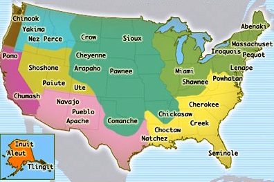 |
| Indian Lands in the USA: Note the Navajo/Pueblo/Apache Territory (Source) |
The modern term Apache excludes the Navajo people. Since the Navajo and the other Apache groups are clearly related through culture and language, they are all considered Apachean. Apachean people formerly ranged over eastern Arizona, northern Mexico (Sonora and Chihuahua), New Mexico, west and southwest Texas, and southern Colorado. The Apachería consisted of high mountains, sheltered and watered valleys, deep canyons, deserts, and the southern Great Plains.It would seem that when the United States absorbed the Republic of Texas, and especially after the U.S. land acquisitions in the 1840s relating to the Mexican-American War, Texas expanded to its current size. Eventually, U.S. military force eliminated military threats to Texas from the Apaches and Comanches.

No comments:
Post a Comment