 |
| Source: The New York Times |
(The map is based on) six data points for each county in the United States: education (percentage of residents with at least a bachelor’s degree), median household income, unemployment rate, disability rate, life expectancy and obesity. We then averaged each county’s relative rank in these categories to create an overall ranking........
The 10 lowest counties in the country, by this ranking, include a cluster of six in the Appalachian Mountains of eastern Kentucky (Breathitt, Clay, Jackson, Lee, Leslie and Magoffin), along with four others in various parts of the rural South: Humphreys County, Miss.; East Carroll Parish, La.; Jefferson County, Ga.; and Lee County, Ark........
Six of the top 10 counties in the United States are in the suburbs of Washington (especially on the Virginia side of the Potomac River), but the top ranking of all goes to Los Alamos County, N.M., home of Los Alamos National Laboratory, which does much of the scientific work underpinning the U.S. nuclear arsenal. The lab directly employs one out of every five county residents and has a budget of $2.1 billion; only a fraction of that is spent within the county, but that’s still an enormous economic engine for a county of just 18,000 people.
Here are some specific comparisons: Only 7.4 percent of Clay County residents have at least a bachelor’s degree, while 63.2 percent do in Los Alamos. The median household income in Los Alamos County is $106,426, almost five times what the median Clay County household earns. In Clay County, 12.7 percent of residents are unemployed, and 11.7 percent are on disability; the corresponding figures in Los Alamos County are 3.5 percent and 0.3 percent. Los Alamos County’s obesity rate is 22.8 percent, while Clay County’s is 45.5 percent. And Los Alamos County residents live 11 years longer, on average — 82.4 years vs. 71.4 years in Clay County.The poorest parts of the country are the old south and Appalachia. The California coast and the eastern seaboard do well. I note that there is a big blue area (doing quite well) in the northern mid-west, what I think of as the agricultural heartland of the country. The orange areas included in that blue are likely to have large Indian reservation populations. The counties there are big, suggesting that when they became states they were sparsely populated, and I suspect they still have relatively few members of the House of Representatives per Senator. These would be Republican heartland (see map below), benefiting from strong government support for agricultural interests.
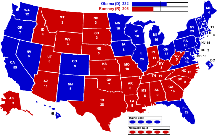
I am not sure that the poor counties of the south are natural political allies for the better off counties of the Dakotas, Nebraska, Montana and Wyoming.
2012 Presidential Election Results
No comments:
Post a Comment